


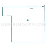
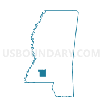
Government Complex Voting District, Lincoln County, Mississippi
About
Outline

Summary
| Unique Area Identifier | 606088 |
| Name | Government Complex Voting District |
| County | Lincoln County |
| State | Mississippi |
| Area (square miles) | 0.43 |
| Land Area (square miles) | 0.43 |
| Water Area (square miles) | 0.00 |
| % of Land Area | 100.00 |
| % of Water Area | 0.00 |
| Latitude of the Internal Point | 31.57009790 |
| Longtitude of the Internal Point | -90.44117780 |
Maps

Graphs
Select a template below for downloading or customizing gragh for Government Complex Voting District, Lincoln County, Mississippi


Neighbors
Neighoring Voting District (by Name) Neighboring Voting District on the Map
- Alexander Jr. High Voting District, Lincoln County, MS
- City Hall Voting District, Lincoln County, MS
- Forrestry Voting District, Lincoln County, MS
- Old Brook Voting District, Lincoln County, MS